Mam Tor, Peak District UK

I’m still undergoing my hiking training in preparation for the trek in Transylvania to raise money for Mind. So in search of seeking out some good local places to walk, we set off for the Peak District, which is about an hour or so away from where we live.

Mam Tor was our destination; a rather large hill in Castleton. With an elevation of 515m, it was the perfect training ground for me.

We’d decided to take the circular route from Castleton as this would give us a total walking time of around four hours. Ignoring all sound advice from the lady in the visitor’s centre (because who wants to do things the easy way?!), we set off in the opposite direction, towards the steep climb out of a fairly dramatic looking valley. Walking up the side of the road towards Speedway cavern and Blue John Mine, the scenery was impressive, making me feel quite ‘hobbit-like’ due to the size and greenery of the hills surrounding us.

After a bit of creative navigation (we were following this brilliant guide but the signs aren’t great for the path), we found two routes up Mam Tor. We pot-lucked our way up the path to the right, eventually reaching what resembled a slight scramble up the hill to reach the main path. About half way up, I heard one woman remark to her walking partner “Oh I’m glad we are coming down this way rather than scrambling up, that route would have been awful“. Gee thanks lady. As you’ll have guessed, she was travelling in the opposite direction to us, making me wonder if I should have chosen the left path after all.

At the top of the scramble was a clearer path, steeply rising up the hillside. Given that we were fairly near the edge, my unhelpful feeling of ‘wobbliness’ started to surface. I’m not necessarily afraid of heights, but they do make me feel incredibly unstable. I fixed my eyes to the ground and just focused on putting one foot in front of the other. Before I knew it, we were at the top with an amazing view. We stayed for a while watching people paraglide whilst we had lunch.

A little side note: John West tuna lunch pots seem to have become my hiking lunch of choice. There is a gluten free / dairy free one and it’s easy to pack in a day sack. It’s either that or chocolate spread on gluten free bread – either way, I seem to have become stuck in a kind of lunch ‘dead-end’ – if other people have better hiking lunches – let me know!!!

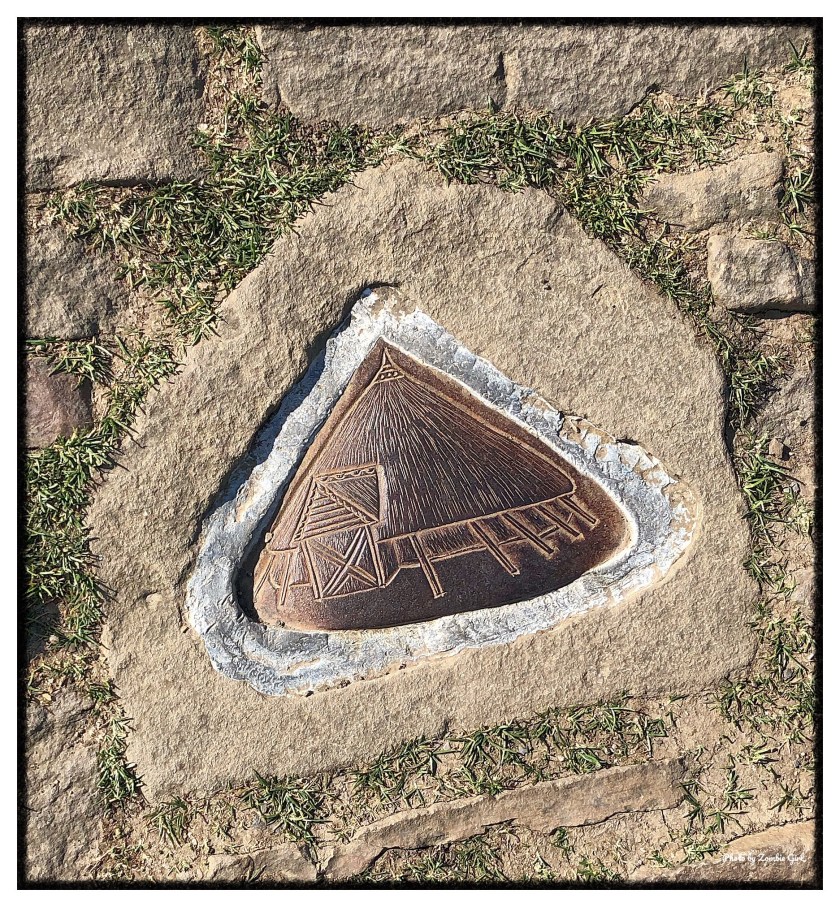
At the top of Mam Tor was a trig point surrounded by little stone images of faces and huts – if anyone knows what their meanings are, I’d be interested to learn!

Looking over to the right, we could see the other path up the hill, which looked far easier and much less steep, but at least I’d had a good work out and pushed myself on a couple of ridge edges.

Once we were suitably fed, watered and recovered from the climb, we set off to the left along the marked stone path. This was much easier going and it became clear why the lady in the visitor’s centre has suggested to take this route. Coming up this path was a much gentler incline and would have much more clearly marked the route.

Passing Black Tor and Lose Hill Pike, we then started to cross a beautiful wooded area which was more stunning (to me at least) than the moors and fields. There is a pull I feel towards trees and woods that I just don’t experience in fields and out on the moors. It’s like an automatic ‘mood-boost’ and I feel much more connected to my surroundings.

Whilst the valley had been beautiful to drive through on the way to Mam Tor, it was the small tree lined area that stuck in my mind long after the walk.

Heading out of the trees and into the fields, our sense of direction failed us again as the path became unclear. A mother and daughter pair were also struggling with the route and we took it in turns to follow each other, sharing confused discussions on the same maps we were using.

Eventually, we crossed Spring House Farm and headed back towards Castleton. Next time, I’d look to extend the walk by heading to Hope first and then back to Castleton and maybe also taking some time to visit Peveril Castle, which looked intriguing, perched up high, keeping watch above the village.

Half Dome: Vernal Falls

Half dome is not for those who are only half prepared. We prepped *a lot* and we only made it to the subdome. Only is a funny word though. For me, only reaching the subdome isn’t a failed attempt. What some would call failed, I call successful (and arguably one of my biggest achievements).

Half Dome is probably one of the most iconic sights of Yosemite National Park. It’s hulking outline stands tall over the whole park and it’s easy to see why it’s the one sight that everyone wants a photo with.

Our journey on Half Dome actually started a couple of visits back when we first stayed at Yosemite. Three friends with ambitions of making it to the top. We were fuelled with the optimism of those who have never attempted it before and bolstered by the sense of adventure that can only arise from watching ‘In to the Wild’ in a tent in the middle of Wawona the night before. We thought we could conquer it with gusto. That’s not to say we came to it green – we’d done our research; training as much as we could by getting hiking trips in back home (although to be fair, nothing like the height of Half Dome) and we’d kitted ourselves out in all of the right gear.

On that first occasion, we started out on the wrong foot by setting off far too late for the trek. By the time we had driven from Wawona to the trail head in Yosemite Valley, it was probably about 9am. Although this sounds fairly early, most people recommend that to get to the top and back in good time, you should be planning to set off on the first part of the trail at around 4/5am. As the first part of the pathway is paved, this makes sense. Trust us, you want to make up time on the way up as coming down the route in the dark because you have set off too late is no fun at all.

Getting ready for the hike is no mean feet either. The whole trail takes around 10-12 hours walk, gaining an elevation of 4800ft (8,800ft above sea level). Being prepared is so important. For me, this meant 2 hydration packs, 2 additional bottles of water, breakfast and lunch and lots of energy boosting snacks. That’s a lot to carry on your back for a hike or this length but, it is absolutely necessary!

The first section of trail is only about a mile or so of paved pathway, but it’s very steep (at this point of the trail, we were 4500ft above sea level). After a short hike up this path, the water fountains at the top are a very welcome sight. This is the last place to get water on the half dome trail (and also the last place for flushing toilets – prepare yourself!!). I have to say, this water is the best I have ever tasted. Ever. I actually ended up emptying one hydration pack and filling it up with water from this fountain instead. It’s that good, and I’ve tasted water from a glacier). I have no idea why it tasted so amazing but every time we have decided to do the half dome trail (about 3 times), the thought of that water fountain has been my motivating factor for getting to the top of the first mile!

After passing the footbridge just past the water-stop, the steepness increases massively as huge stone steps lead up to the first major waterfall on the trail; Vernal Falls. This part of the hike, although strenuous, is stunning. The steps are cut into the side of the waterfall, meaning that the water roars down to your left as you ascend. We’ve done this trail in the middle of summer and early spring. In summer, the steps are hot and dry, but in the spring it’s clear to see how the Mist Trail gets its name. In a huge contrast to the first time we took this trail, visiting in spring left us soaked! The force of Vernal Falls generated a spray which make us feel like we were hiking up the middle of the waterfall rather than the side. It was slippy and soggy work, but by the time we got to the top of the waterfall, we were grateful for the cooling effect of the spray.

The top of Vernal Falls was incredible. At 5000ft up, rushing of the water and the view across the valley below made the hard climb all the more worthwhile.

Happiness Only Real When Shared: Reflections From The Top of Sulphur Mountain, Banff.

We look back at our favourite image from 2017

As we hurtle towards the end of the year, we thought that we would look back on the year until now. 2017 saw the launch of this blog and it’s great to have been able to share some of our adventures with you!

Helpfully, the daily post’s photo challenge this week was on the topic of favourite photos from this year. With this in mind, me and Wandering Beeb went digging through our photos to see what we would class as our favourites.

Some of the stand out ones from this year were our ‘walking the glacier‘ set – just because the experience was so surreal and so different to our usual trips.

The photos on Sulphur Mountain in Banff grabbed us and made sense for us to share on this theme, although probably not for the reasons you would think!

Sulphur Mountain was impressive, with stunning views on a near 360 degree viewing platform. We were lucky in that the haze from the forest fires had cleared a little, moving the view of the mountains from a fuzzy outline in the distance to 3D relief, affording us some stunning vistas. We made the short trundle from the observation deck to the now defunct Cosmic Ray Station, heading up inclines made manageable for most visitors by structured steps and under-foot decking. So much so that a small child was walking confidently the length of the observation deck, loudly proclaiming ‘Eeek’ to the surrounding mountains, blissfully unconcerned with the breath-taking drop below. Looking back at the photos, the views are clearly stunning, but this wasn’t the reason for singling them out.

One of the best things about travelling is speaking to other people from different cultures, countries and perspectives – even when it’s only briefly. Those snippets of conversation are what add flavour to the otherwise routine trawl through the sightseeing gambit and it was the connections we made on this part of the trip that we were reminded of by these photos.

Whizzing along on the upward gondola trip, we found ourselves sharing the four person gondola with two guys who were catching up on a trip out to Banff. They explained that they had been neighbours 10 years earlier, with one of the pair only being a kid at the time. Learning about two people and their stories in an 8 minute ride up the mountain can only give you a flavour of their history, but we had the sense that they were two really cool guys, enjoying their time catching up. There was an easy-going banter between the two of them which helped to reduce my anxiety at being suspended above the ground by a single cable.

The way down saw us sharing the space with a couple from Sweden who were clearly as freaked out by the height as I was (you can read more about my terrible relationship with gondolas here).

Despite the anxiety, we talked about their trip, starting with Reykjavik, heading on to Quebec and learning about their observations on Toronto (a smaller version of NYC). We shared our views on Vancouver (to which they were heading soon). They took a couple of snaps and asked us about our football preferences back home in the UK (Zatan was a favourite topic of conversation). As soon as people find out we are from Manchester, the first question is always ‘are you a red or a blue?’ By the time the gondola had reached the bottom and we wished each other happy travels, we had shared travel tips, made new acquaintances and had some ideas for our future travels. It’s those memories that have made these photos some of our favourites. 

This is our favourite part of travelling and regardless of beautiful scenery and amazing experiences, it’s the people and the connections that makes the journey worthwhile.